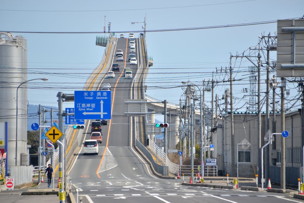
Eshima Ohashi Bridge connects Sakaiminato in Tottori Prefecture with Eshima in Matsue, Shimane Prefecture, across Lake Nakaumi. It became internationally famous because photographs taken from the Shimane side can make the roadway look almost vertical, earning it dramatic nicknames online. In reality, the climb is far gentler than those compressed-perspective images suggest, and the bridge is a practical transport link that also offers wide views across the lake toward Mt. Daisen.
For travellers exploring western Japan, Eshima Ohashi is an unusual stop that combines engineering, photography and regional scenery. It is especially easy to pair with attractions around Sakaiminato, Yonago, Matsue and the Mt. Daisen area.
Key Takeaways
Eshima Ohashi Bridge Quick Facts
| Location | Between Sakaiminato, Tottori Prefecture and Eshima, Matsue, Shimane Prefecture |
|---|---|
| Length | Approximately 1.7 kilometres |
| Gradient | 6.1% on the Shimane side and 5.1% on the Tottori side |
| Completed | 2004 |
| Nearest practical rail access | Sakaiminato Station, about 2 kilometres away |
| Typical access | By car, bicycle, or on foot from the Sakaiminato side |
The bridge is a working road rather than a conventional ticketed sightseeing attraction. Official tourism information focuses on access by road, bicycle and walking, so visitors should treat it as transport infrastructure first and a scenic viewpoint second.
Why Does Eshima Ohashi Bridge Look So Steep?
The most famous photographs are usually taken from the Shimane side, where the bridge appears to rise sharply into the sky. That visual effect is much more dramatic than the actual incline. Japan National Tourism Organization lists the gradient as 6.1% on the Shimane side and 5.1% on the Tottori side.
The bridge rises high enough to let vessels pass beneath it, reaching roughly 45 metres above sea level according to Matsue tourism information. When the bridge is photographed from farther away with a long focal length, the foreground and background appear compressed, making the climb look much steeper than it feels when you are actually crossing it.
A famous bridge, but not an extreme roller coaster
Eshima Ohashi became widely known after appearing in a Daihatsu car advertisement and later in international media and social posts. The extreme-looking perspective helped create the bridge’s internet reputation, but it is more useful to think of it as a distinctive high bridge with a photogenic approach rather than a dangerous stunt road.
Where to Photograph Eshima Ohashi Bridge
The classic view is from the Shimane side, looking toward the bridge from around the intersection near the approach. JNTO specifically identifies this side as the place to capture the well-known steep-looking composition.
If your goal is the dramatic “wall of road” effect, standing farther back and using optical zoom or a telephoto lens will usually create a stronger compressed perspective than shooting close to the base. Do not stand in traffic lanes or block local access while taking photographs. The bridge is active infrastructure, and safe positioning matters more than reproducing a viral angle.
From higher points on the bridge, clear weather can reveal broad views across Lake Nakaumi toward Mt. Daisen. Travellers interested in the mountain can also consider Daisenji Temple, Ogamiyama-jinja Shrine Okunomiya and Daisen Falls when building a wider Tottori itinerary.
Can You Walk or Cycle Across Eshima Ohashi?
Official tourism guidance states that visitors can walk or cycle to the centre of the bridge. This can be a good option for travellers who want to experience the height and scenery without driving, but the bridge is exposed to weather and traffic. Wind, rain, heat and winter conditions can make the crossing less comfortable, so check local conditions and use the designated pedestrian or cycling space.
Because the bridge is approximately 1.7 kilometres long, remember that a full out-and-back crossing takes considerably longer than simply reaching the high point. If you are walking from Sakaiminato Station as well, allow extra time for the approach and return.
Accessibility considerations
The sustained incline is the main practical challenge. Travellers with limited mobility, small children or anyone who finds longer uphill walks difficult may prefer to view the bridge from the approach area or cross by vehicle instead of walking the full span. Official tourism sources do not present Eshima Ohashi as a managed visitor attraction with dedicated accessibility services, so plan conservatively.
How to Get to Eshima Ohashi Bridge
From Sakaiminato Station
JNTO places the bridge at around two kilometres from Sakaiminato Station, or roughly a 30-minute walk. This makes the station the most straightforward public-transport starting point for travellers already exploring the Sakaiminato area. Cycling can shorten the approach and is also mentioned by official tourism guidance.
While in the wider Yonago and Sakaiminato region, nature-focused travellers may also want to visit the Yonago Waterbird Sanctuary, while photography enthusiasts can continue to the Shoji Ueda Museum. If you are staying overnight nearby, Kaike Onsen is another useful regional stop.
From Matsue and the Shimane side
Eshima is part of Matsue City and sits within the Lake Nakaumi area. Travellers based in Matsue can combine the bridge with destinations such as Matsue Castle, Lake Shinji and Daikon Island (Daikonjima). On the eastern side of the Matsue area, Miho-jinja Shrine offers a very different historic and coastal experience.
Driving is generally the simplest way to combine several of these places in one day. If relying on public transport, check current regional train and bus timetables before travelling because connections outside major city centres can be less frequent.
What to See Around Eshima Ohashi
Eshima Ohashi works best as part of a broader San’in region itinerary rather than as a full-day attraction by itself. On the Tottori side, the Tottori Hanakairo Flower Park sits near the Mt. Daisen area and is a strong option for gardens and seasonal scenery. Tottori City is farther east but has several major attractions that can fit into a longer prefecture trip, including the Tottori Sand Dunes, the nearby Sand Museum and the historic Tottori Castle Ruins (Kyusho Park).
If your visit coincides with summer events, the Yonago Gaina Festival provides a cultural contrast to the bridge’s modern engineering. Travellers continuing into Shimane can explore the Shimane Museum of Ancient Izumo, while those heading farther offshore may be interested in the Oki Islands UNESCO Global Geopark.
Best Time to Visit
For photography, clear weather gives you the best chance of seeing Lake Nakaumi and Mt. Daisen. Morning or later-afternoon light can also add more shape and contrast to the bridge, although conditions vary by season.
Because this is an exposed bridge, weather matters more than conventional attraction opening hours. Strong wind, rain, extreme heat or icy winter conditions may make walking or cycling unpleasant. Check the local forecast and any road or transport notices before setting out.
Practical Tips for Visiting
- Allow enough walking time: the bridge is about two kilometres from Sakaiminato Station, before you even begin a full crossing.
- Bring a zoom lens if photography is your priority: the famous steep appearance is strongest from a distance.
- Respect traffic: use pedestrian or cycling areas and avoid stopping where you obstruct vehicles or local residents.
- Check visibility: Mt. Daisen is most rewarding on a clear day.
- Pair it with nearby sights: the bridge itself does not require a full day, so combine it with Matsue, Sakaiminato, Yonago or Mt. Daisen.
- Verify current conditions: transport schedules and temporary traffic restrictions can change.
Frequently Asked Questions
Is Eshima Ohashi Bridge really as steep as it looks?
No. The famous photographs exaggerate the visual impression. The official gradients are 6.1% on the Shimane side and 5.1% on the Tottori side.
How long is Eshima Ohashi Bridge?
The bridge spans approximately 1.7 kilometres across Lake Nakaumi between Tottori and Shimane prefectures.
Can visitors walk across the bridge?
Yes. JNTO states that visitors can walk or cycle to the centre of the bridge. Weather and traffic conditions should still be considered before crossing.
What is the nearest station?
Sakaiminato Station is the most practical rail access point mentioned by JNTO. The bridge is about two kilometres away, approximately a 30-minute walk.
Where is the best place to photograph the steep-looking bridge?
The classic view is from the Shimane side, near the road approach and intersection. A longer focal length can strengthen the compressed-perspective effect while allowing you to stay farther back from the bridge.
Sources and Further Information
- Japan National Tourism Organization (JNTO): Eshima Ohashi Bridge
- Visit Matsue: Lake Nakaumi and Eshima area
Address And Maps Location:
Yatsukacho Eshima, Matsue-shi, Shimane-ken
Find Location And Direction On Google Maps
Subscribe, follow travelbloggerindonesia.com
Originally posted 2024-04-08 06:17:06.